Mobile mapping company
Definition Mobile mapping

Mobile mapping definition

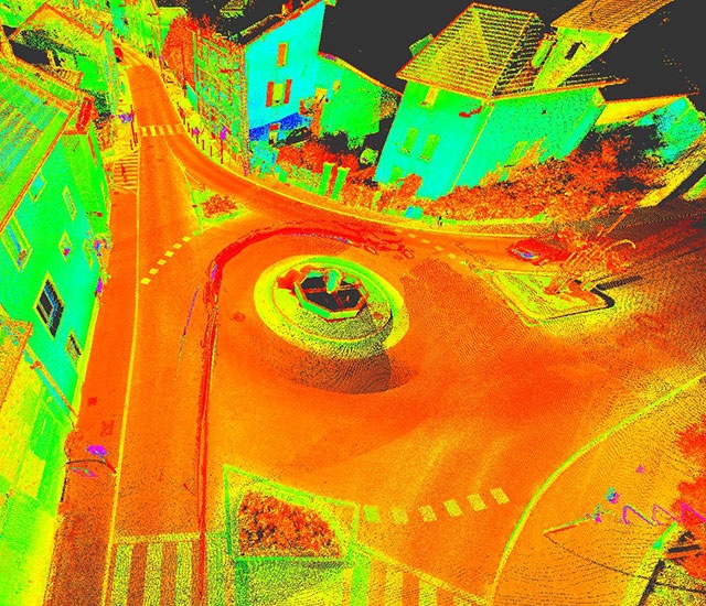
Mobile mapping, also called dynamic scanning, is a process of collecting large-scale 3D data from a moving vehicle. Powerful and fast, this type of system also makes it possible to associate a vehicle-embedded scanner with cameras providing 360° images.

Mobile Mapping - 3D laser scanning services

In just a few years and with the development of highly productive large scale 3D data acquisition systems, mobile mapping (or road mapping) has become an essential tool in terms of acquisition of data for GIS and land use planning assessments. Our company is equipped to set up complex mobile mapping systems thanks to the expertise of our specialized engineers.

We efficiently handle all phases of mobile mapping services including:

  • Sensor calibration,
  • Geo-referencing, control points,
  • On-site acquisition,
  • Post-processing, dot plot calculations,
  • 2D and 3D vectoring and modeling.

To produce an optimal quality deliverable, our teams pay particular attention to adjusting acquisition parameters (speed and number of passages and to geo-referencing the trajectory (number and accuracy of control points). The company has its own in-house mobile mapping equipment (Pegasus Two system from Leica) to guarantee fast turn-around times and optimal efficiency.

Sintégra, thanks to its multidisciplinary skills and extensive expertise in topography, uses complementary acquisition techniques for complex projects. These include:

  • Airborne lidar or aerial photogrammetry to cover zones located outside of corridors scanned from the ground vehicle,
  • Static terrestrial lasergrammetry in hard to reach or confined zones, or when higher resolution is needed,
  • « Pedestrian » mobile mapping using light, manual dynamic scanners,
  • Traditional topography using a tachometer, when specific, accurate points need to be surveyed,
  • Bathymetric surveys of underwater zones possibly included in the assessment zone.

Our mapping and surveying firm delivers solutions to clients in France and abroad (Europe, Maghreb, Sub-Saharan Africa, Middle-East, etc.).

Mobile mapping applications

After assembly and georeferencing, the 3D data collected can be used to produce results adapted to all types of requirements:

  • Topographic maps:
    • Road and highway systems,
    • Industrial infrastructures,
    • Rail lines,
    • Simplified street maps,
    • GIS (Geographic Information System)…
  • 3D modeling:
    • 3D city models,
    • Urban furniture,
    • BIM…
  • Sizing assessments:
    • Tunnel, galleries,
    • Road and highway structures, overpasses, underpasses…
  • Safety assessments:
    • Pavement geometry,
    • Slide rail height,
    • Signage…
  • Surveys of industrial infrastructure on production sites:
    • Factory,
    • Storage areas,
    • Quarries…
  • 360° photographic panoramas


Technical equipment

In 2014 the company acquired a Leica Pegasus Two System integrating:

  • An ultra-high frequency laser profiler Z&F 9012, with 8 cameras,
  • A GNSS navigation system,
  • An inertial unit (IMU),
  • An odome

The compact Pegasus system can be mounted on any type of vehicle and can perform all types of topographic surveys with a very high level of accuracy and efficiency.

In the road and highway field, surveys can be performed without interrupting or disturbing traffic as the vehicle drives at the same speed as other users.


The data captured by current mobile mapping systems are processed using dedicated software:

  • MapFactory for ArcGis
  • TerraSolid suite

They can also be displayed using big data type solutions, allowing interactive sharing via web streaming between different people involved in the same project.

Photo/scanner coupling is used to color point clouds, easily identify equipment (manholes, road markings, various equipment…) and distinguish between the different materials within the point clouds.

The different 2D and 3D products resulting from post-processing can be exported into the format needed by the client (vector maps, cross-sections, 3D models, DTM, DSM, tables of data and deformations, etc.)
références

GEF / SFTRF / SITAF – Tunnel du Frejus

(France – Italie)


Levé complet (13 km) – Cartographie du gabarit pour étude de sécurité.

APRR / AREA – A41-A43-A48-A49-A51-A410-A432

(France)


Levé complet (490 km), données attributaires par PK, étude de sécurité.

ALTEA – RD302

Rhône (France)


Plan topographique au 1/200 – Récolement pour étude de réhabilitation.

St-Etienne de St-Geoirs

Isère (France)


Modélisation de bâtiments avec texture photoréaliste à partir du nuage de points et des images acquises par notre système Pegasus Two pour réalisation d’une maquette virtuelle.